UK Circumnavigation

Jenny's two months of sailing, starting at Suffolk Yacht Harbour and heading north to the Caledonian Canal and eventually all the way around the UK ( weather permitting ). I will be meeting friends on route who will share the sailing. Jenny's homepage http://www.jsquared.co.uk/jennyb and the link to Serenity http://www.yacht-serenity.org.uk/

Thursday 31 July 2008

Falmouth to Plymouth

Monday 28/7/08
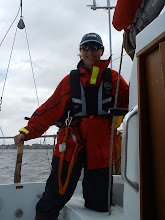
The weather was rather grey on the way out from Falmouth, slightly choppy with the wind on the beam.


I was just about to get the mainsail up when I noticed that the main halyard had wrapped itself around the radar reflector, and being single handed, I did not want to play around on the foredeck unless I really had to. So it was a motorsail to Plymouth across the bay. Again, there were quite a few other yachts around, often on reciprocal courses.
Arriving in Plymouth in the rain, I was hoping to make my way to Sutton Yacht harbour to be near to the town, and as per usual the phone numbers given in the almanac ( both landline and mobile ) were not being answered. I called on the radio once in the harbour actively dodging the dinghies, and found that Sutton was full, and so was Queen Annes Battery Marina. Luckily they had space for me at Plymouth Yacht Haven. It really is worth phoning ahead to confirm a berth.
I arrived and dried out.

St Ives to Falmouth

Friday 26/07/08
I was awake at 04:00 and away before 05:00 in the dark. According to the almanac, a passage from the North to South around Lands End should use the close inshore counter-flows of tide, and this will involve running against the tide from St Ives to Lands End.
Sunrise.

We arrived outside The Brisons at about the right time, but seemed to have the tide against us all the way round.


I guess that we were not close enough to shore to catch the flow. Moving across Sennen Cove and inside Longships and outside Runnel Stone, the tide started to push us around.


At this point, we could decide to either stop at Newlyn or push on to Falmouth, and as it was still early in the morning we pushed across Mounts Bay towards Lizard Point.
The Lizard was surrounded by a thick bank of fog, but it was close inshore so we gave it some space as we rounded the Lizard.

The visibility was a couple of nm on the final run to Falmouth and as we approached we saw a huge amount of yachts and dingies - this was after seeing one or two at a time over the last week - we navigated our way through these and attempted to find a marina for a couple of days as Nick about to go home.

Wednesday 30 July 2008

Padstowe to St Ives

Friday 04/07/08
We planned ahead knowing that we would be either on a visitor's mooring or at anchor when we arrived at St Ives bay, so we stocked up with diesel, meths, water and pasties. I was very impressed by the practicality of pasties for sailing, there are easy to warm ( 12v microwave ), easy to eat, and the seagulls eat the leftovers. They also have an excellent veggie and vegan range here in Padstow, together with fruit pasties. Yummy.

We left to catch the start of the SW tide, again the River Camel looked very inviting on the way out, but this time at high tide.


I noticed that as we were heading out to sea, the engine speed to RPM seemed too slow, so I managed to get the boathook underwater to the propeller and snagged some orange fishing line, apparently around the prop again. Rather that get all the diving kit on, I decided to just go for swimming costume and snorkel. It was very cold. Once I got my breath back after entering the water, I dived under the boat and had to cut away the orange twine and seaweed. The engine was back to running, but I was cold for hours after.

Rather than take the direct course from Padstow to St Ives, we followed the coastline. Nick is a keen photographer being too far out to sea for decent photos is frustrating.

We arrived in St Ives bay, and looked for likely visitors moorings that stay afloat - we needed to leave at low tide on Friday. I really could not identify any moorings, they all could have easily been pot buoys. No answer again from the HM number from the almanac. So we dropped anchor in 5m ( 10kg Delta ), it took beautifully and St Ives gave us a nice selection of transits to make sure that we were not drifting.

The only other vessel in St Ives bay was a wooden square-rigger anchored. About an hour after we arrived, she raised anchor and fired a couple of small cannon whilst she circled us. This was all very surreal and entertaining.


A wonderful quiet night at anchor in St Ives Bay, only slightly clouded by the 05:00 start the next morning.

Sunday 27 July 2008

Clovelly to Padstow

Thursday 24/7/08
We raised the anchor and raised the sail with one reef. The wind was ideal for a change. The route was headland to headland down the coast to Padstow, and to keep us occupied, a large group of dolphins joined us for over 15 minutes. We both took some video and tried to get photos, they were fantastic.
We arrived at Padstow too early for the lock, but we made our way to the outer harbour carefully finding the channel with the FLS and the Navman depth sounder. Neither were that good in the shallow ( where you actually need them, I might have to get a lead line ) but we moored up and used the tender to get ashore and search out Rick Stein's chip shop. The queue was long, but moving quickly. His chips were the best I've ever tasted.
We got back to the tender to find that the tide had come in quicker that I had thought, and I had to wade into the water to recover the tender.
The inner harbour was crowded, and most people seemed to be rafted one way or another.

Padstow and the River Camel in general looked like a very fine holiday destination, I'll have to visit there again by land.

Milford Haven to Clovelly

Wednesday 23/7/08
Leaving Milford Haven was as complicated as our arrival, and once out to see we were visited by a very friendly Range safety boat to advise us that they were firing 'some big stuff' on the range that day and we should stay well clear. Later we felt rather than heard the gunfire.
The wind was stronger than predicted, and the tide seemed against us, together with an unpleasant choppy sea. We looked at our options. I wanted to visit Cardiff, but that was the opposite direction, we could have gone back, but we eventually decided to move on to Lundy hoping the anchorage would be ok.
As we approached Lundy, the wind had eased, but the forecast threatened F6 later and that would make the usual anchorage untenable, so we chose the west anchorage in Jenny's Bay. We anchored as close in as we could to avoid the wind, but after half an hour decided that the swell from the west was too great to stay.

Plan 'B' was Clovelly, but we would not get there until after dark. Not a good prospect, but the best option.
We crossed some passing cargo vessels, and when the AIS reported a close encounter, I called one up and he very kindly altered course to pass behind us. This helps you feel safe in the dusk.
It was difficult to find Clovelly, the lit buoy was invisible, and we used a powerful torch to search for visitors mooring buoys, but we could have mistakenly picked up a crab pot instead, so we anchored, badly, then anchored again.
The wind got up and it was quite choppy, and I got very little sleep.

Fishguard to Milford Haven

Tuesday 22/7/08
The almanac was very specific about tides when rounding St David's Head. We needed to get to Ramsey Sound at slack water, and then take Jack sound as we found it. It was a quiet sunny day as we left Milford Haven, but we had to head into the 2kn tide for 10nm in order to arrive at slack water. In the end, we were about an hour after slack, but the passage through Ramsey Sound was easy with 4kn of tide behind us.

It was a quiet trip across St Brides bay where we started to see anchored tankers on AIS.
Jack sound was a little more exciting, but easy enough as long as you are able to dodge the high speed rhibs taking tourists to the caves.


On entering Milford Haven, Nick recognised the Landmark Trust property where he had stayed some time back.


We had to negotiate the busy port of Milford haven, with tankers moving in and out. The Orwell ( my home estuary ) was excellent practice for this, I stayed well out of their way, I know how fast they can be on top of you.
The gas and oil terminals were very impressive as we passed.


We arrived at Milford Haven lock about an hour early and rafted up with about 10 other boats in the lock to wait.
Milford Haven Marina was good, although the wifi was inaccessible. I found a chandler for more charts, and Nick found a Tescos for chocolate and other supplies.

Aberystwyth to Fishguard

Monday 21/7/08
Nick has arrived as the new crew, and we leave Aberystwyth into some swell and wind good enough for motorsailing after a little playing about with the rigging.

Nick is impressed by the course kept by the Navman autopilot, although he does like to helm very now and again. We see a couple of dolphins pass us by, but not in time to get the camera.
I was slightly worried about the facilities that we might find at Fishguard, the Almanac the the Pilot where not very detailed so I phoned ahead the the harbour master for the lower harbour. I did not want to dry out, as we had to leave at a specific time the next day to round St David's Head.
He indicated that the yellow mooring buoys were in deep enough water and should allow us to get away at any time, and these were obvious once we got into the bay. I had previously purchased a bosco mooring hook and this failed to grab the mooring buoy again ( I must have my technique wrong ) and so we grabbed the buoy by hand. To get to shore we inflated the tender and rowed to the slipway past a huge group of Sea Cadets afloat learning new skills.
Our first stop was the very friendly Yacht Club, and then up the steep hill into town to find a great choice of restaurant.

All in all, Fishguard was idyllic, waking up to a quiet mooring is wonderful.

Tuesday 22 July 2008

Pwllhelli to Aberystwyth

Wednesday the 16th :
The wind was forecast F4-5 from the South, and was therefore a beat across Cardigan Bay to Aberystwyth avoiding the St Patrick's Causeway that blocks the direct route, I did ask the harbourmaster if there was a way through, but apparently the only way is around the causeway.
It was head into wind until we turned to port at the causeway cardinal ( littered with pot buoys ) and then a fast sail towards Aber. Identifying the route onto Aber harbour was difficult, and shallow at times, but we ended up verifying our route with the plotter and FLS rather than the leading lines.

The wind and swell look very unpleasant for the next few days, too poor to pass St David's Head, so Phil left on Thursday. I plan to continue sailing with Nick - my new crew when the weather improves.

Saturday 19 July 2008

Port St Mary to Port Dinorwic

We planned to leave Port St Mary once the tide turned for a port on the Northern edge of Anglesey and the wind was ideal for a sail, so we made steady progress away from the Isle Of Man.

The wind lightened and we slowed, but both of us felt reluctant to start the engine, and in the end we realised that we were going to arrive at Anglesey in the dark, so we might as well head directly for the NE entrance to the Menai Straight. The wind increased, together with the swell and as the tide turned, we were bashing into the waves in the dark - all very unpleasant. Eventually we began to come into the shelter of Red Wharf Bay and dropped anchor in the dark for a couple of hours before the tide turned again into the Menai. It was now 02:00 in the morning.

After a cup of tea and some chocolate, there was a little daylight in the sky, and within 30 minutes it was a grey drizzly dawn. Yeuch.


Passage down the Menai was a mixture of challenging pilotaqe and uneventful sailing , but a terrific experience.


We caught the swellies at slack tide and so the passage was very smooth, and found our way to Port Dinorwic at high tide when the lock opens.

We locked in, rafted up next to a very noisy road bridge and got a few hours sleep.

Bangor ( NI ) to Port St Mart ( IOM )

I started off with probability of a Migraine as we started out from Bangor, I just rather assumed that it would disappear as we passed islands out of Belfast Lough. We'd had a change of crew, and was now accompanied by Phil who had taught me to sail in the early 1980s when I crewed for him in his 'Hornet' dingy. The wind was ideal for sailing, although we were motorsailing under jib, and I could not quite get myself to get the mainsail up as I was not feeling too good. I decided that I really was not feeling well, and took a some migraine treatment, but too late and I spent the next few hours being seasick, or lying in my cabin. Luckily Phil is a very experienced sailor. We were heading for Port St Mary on the East side of the Island, and that would either require a route around chicken rock, or a passage through Calf Sound with the tide against us. The water was very disturbed with the swell and the tide flow, but Phil took us through, with only a couple of kn of flow against us. I missed the opportunity to photograph the route through Calf Sound as it was all a bit intense, but here is a view back onto the sunset

Phil knew Port St Mary well as he had learnt to sail here. We moored up against the seawall at a ladder leaving long mooring warps to cope with the tide drop, although the correct place for yacht mooring is towards the shore end of the seawall.

I learnt a few lessons about my ability to sail with a migraine, the effect of the swell and migraine together causing seasickness ( first time in many years ) and when to hand over command to the competent crew.

Tuesday 8 July 2008

Gigha to Bangor via Glenarm

We set out for Glenarm at 06:00 on Friday, with the option of continuing onto Bangor if we felt up to it. This seems to be the way of sailing, to head TOWARDS something, noting that the destination really is up to the weather.

There was a covering of low cloud as we left Gigha, but the sun soon burnt though this as we made progress towards the point of the Mull of Kintyre. The sea became choppy as we rounded the headland, and there were more outfalls as our SOG rose up past 8kn again. It was a smooth sail across the Northern Channel, avoiding the TSS ( Traffic Separation Scheme ) even if we saw absolutely no traffic in sight of us or the AIS.
The tide was with us all the way from Gigha and turned against us a couple of nm outside of Gigha, so we pulled in at lunchtime to wait for the fair tide.

We did not see very much of Glenarm as I caught up with some sleep, but we did notice a lot of Union Flags on the seafront. A great place for a stop-over.
The tide turned in our favour at around 18:00 and we progressed down the coast, but into the wind until we arrived at Bangor Marina, where I found something worth crossing the Irish Sea for - A BATH - it was wonderful. I bought some bubblebath, a magazine and my radio4 radio and had a fantastic soak. Showers are fine, but I always prefer a real bath.

Oban to Gigha

After waiting out the winds for a day in Oban, Phil and I caught the tide south towards Gigha.

We had initially decided to head to Bangor, Northern Ireland via the Crinan Canal and Campbeltown, but talking to Pam and Ted the Crinan can take a while especially with only two people on board. The preferred route was therefore the Isle of Gigha and then Glenarm. This was very good advice.
The tides seem to conspire to make us leave at 05:00, so we set off south with a few other yachts. There is an area of heavy tide flow between Luing and Scarba, so we wanted to get to this point at the right state of tide.

As we passed through marked outfalls and whirlpools on the chart, our SOG ( speed over ground ) hit 11kn with a water speed of 4.5. Outfalls did not seem to be a problem, although steering through them was all over the place. The Whirlpools were worth avoiding.

I did notice that when running the engine, the speed vs engine revs seemed to have dropped, so I made a note to have a look at the prop when we arrived.
We phoned ahead to Gigha, as the almanac says that they only have 9 moorings available, and only 2 were in use as we arrived. After some enquiry at the shop and the hotel, it seems that the moorings were provided by the council and are free to use, together with the toilets and the showers at the landing point.

The water was wonderfully clear, so I decided to put on my drysuit and scuba kit to have a look at the propeller. It looked like a christmas tree made of seaweed. I removed all the fouling, inspected Serenity's hull and fittings, then went for a 15 minute swim around hoping to meet a seal.

The local restaurant provided an excellent meal, and we settled down to a very quiet and comfortable night on a mooring.

Loch Leven to Oban

Tuesday morning we awoke in Loch Leven, bought some provisions from the local shop - we even found some meths for our Spirit cooker.

The forecast was strong wind from the SE F5-7 sometimes F8. We decided to have a look into Loch Linnhe to see what the swell and wind was like. We had enough plan (B), (C) and ultimately turn back options in case the wind was too bad.
We ran against the tide under the A82 to get the tide right to Oban. There were small outfalls, and we only made 1.2kn through the worst bits, even motorsailing with 6.5kn though the water. This flow only lasted a few hundred yards.

The wind was very strong on our beam as we proceeded down the south east coast of Loch Linnhe, we reefed, reefed again and still were too far heeled over. We considered turning back, but found that running under the shelter of the coastline reduced the wind to a manageable level. Surprisingly there was very little swell.
We hugged the coastine, progressing inside the islands passing anchorages, some very wild, and others calm depending on the shelter.

We were both in full sailing kit, harnessed on as necessary.

As we passed the Lynn of Lorne, the wind began to drop and the last of the journey to Oban was a really pleasant set of tacks, avoiding the Ferrys routing between the islands. Oban marina was rather windswept and our arrival on the last of the pontoon spaces was exciting. There are major advantages having a small 27' boat that can fit anywhere.
The marina is opposite Oban on the Island of Kerrera. There is an hourly water taxi to the mainland. Very good facilities including a tumble drier. We spent a day in Oban, collecting new charts from the Chandlers.

Wednesday 2 July 2008

Caledonian Canal to Loch Leven

Leaving Loch Oich for Loch Lochy through another swing bridge and locks onto Loch Lochy. and onto Neptune's Staircase - 7 locks downwards. We now realise that the downwards locking is much easier than upwards locking.


After completing the last of the locks, we dropped Jennifer at the local train station - she had to train to Arbroath to collect the van at 23:30, then drove back to Cambridge in time for work Tuesday afternoon.

Phil and I left the last sealock and headed for Oban into potentially unpleasant weather.


We were not sure how much shelter we would find from the sealoch, and as we made progress out to sea, the wind and waves became stronger, until our progress was very slow. Decided to pull into Lock Leven which was well sheltered against the southerly wind and found another pontoon for the night.

Caledonian Canal 2

Our View back along Loch Ness from Fort Augustus

Sunday, we planned to make our way through to Fort William but we had a very relaxed start at the flight of Locks in Fort Augustus
.
This is where we really started to encounter the hire boats. Some of them were being well cared for, but a few others were definitely worth staying away from. The Lock keepers were very good, and allowed the hire boats to go in first, then the sailing yachts would go in at the back where it was safer.
In the end, we were too late to get out of Loch Oich, so we found a pontoon near to a hotel and tied up for the night.

The Caledonian Canal

We entered the Caledonian Canal on Friday evening though the sea lock

Saturday morning, we entered the first four flight lock and this raised us up towards Loch Ness after a little more canal and another single lock.

There was a 14kn wind against us as we entered, and the ( fresh ) water was very choppy, to the extent that we looked for shelter in the anchorages around the shore of Loch Ness so that we could wait until the wind and waves died away.

About 2/3 on the way along Loch Ness, we found a pontoon at Foyers, and Jennifer and I wandered up the hill to see the waterfalls, and to find somewhere nice for coffee.


The depth sounders showed Loch Ness to be deep. The Navman 8084 peaked at around 233m whereas the Echopilot FLS Gold II decided it was 16m and became derranged.

We made our way to Fort Augustus, where we met Phil - our new crew.